

UPDATE: Wed 8th June 1:30pm:
Another quick lunch-break update.
The weather that was forecasted eventuated. We had a strong front hit the mountains mid-afternoon yesterday which was followed up by solid showers from the SW through the evening and today. This was accompanied by cold temperatures and snow to low levels.
You can clearly see this on The Weather Chaser’s satellite/radar composite which has 24 hours history.
As you will see from the BOM’s 4 day weather chart the Low pressure system continues to move East, and forms a ‘cut-off’ low over the Tasman. These kinds of systems historically have favoured Thredbo due to the orientation of the Valley, and are often too far East to bring significant snow to Victoria, especially Buller. Also they are not as cold as a traditional SW Outbreak that we have just experienced so snow levels are expected to rise tomorrow & Friday. Weatherzone’s Snow page highlights this. However on the upside Buller, Baw Baw and Lake Mountain are traditionally favoured by SW systems so they will do better in the near term.
Here’ is Jane’s Weather‘s take on the situation:
SNOW IN THE ALPINE (>1200 metres)
This is the system that will provide a good, solid base, ready for the ski season.
The flow is S/SW today then S/SE on Thursday and Friday which will be warmer.
All alpine areas should get at least 20 to 30 cm from yesterday through to Friday. The S/SE flow will provide a wetter snow, only on the upper slopes, but will produce a lot of it (particularly Thursday). This will see some areas record over 50 cm up high as the total.
Today: 5 to 10 cm, but up to 20 cm for Baw Baw and Buller – throughout alpine elevations.
Tomorrow: up to 5 cm for Baw Baw and Buller, 10 to 20 cm for Falls and Hotham – only highest slopes.
Friday: up to 5 cm for Baw Baw and Buller, 5 to 10 cm for Falls and Hotham – only highest slopes.
Dry from Saturday.
So it still remains to be seen just how much snow will fall once the winds shift towards the East, and for Victoria, especially Buller I would not be too expectant of further snow once this happens. However NSW skiers could be very well rewarded.
If you are on the mountain and have anything to report or add, please drop us a line in the comments at the bottom of this page.
Remember to ‘Like’ aussieskier.com on the top RHS of this page & follow us on Twitter.
UPDATE: Tues 7th June 1:30pm:
A quick lunch-break update.
Looking at the Radar the precipitation band is just about to hit the Alpine areas.
Jane’s Weather has updated and is predicting siginificant snow, down to very low levels tomorrow but then rising on Thursday:
This is the system that will provide a good, solid base, ready for the ski season.
By Friday it is likely that some of our alpine areas will have received more than 50 cm of snow.
The flow is SW today, S/SW tomorrow, S/SE on Thursday and Friday.
All alpine areas should get 20 to 30 cm. The S/SE flow will provide a wetter snow, only on the upper slopes, but will produce a lot of it (particularly Thursday). This will see some areas record over 50 cm up high.
Thanks Jane for the update.
Once the front hits the forum Observations thread will be well worth reading.
I will get on the phone later this afternoon to some friends on the mountain and update with some first-hand info. I will also start to get a feel for what lifts may run on the weekend.
Remember to ‘Like’ aussieskier.com on the top RHS of this page & follow us on twitter.
UPDATE: Tues 7th June 7:30am:
It looks like it was a cold but dry night in the Alps. No snow to speak of but temperatures under -5c across the region so snowmaking will be progressing at full power.
It’s a bit too early for the forumites to put in their 2 cents, basically they were watching the various different models that had a couple of very different precipitation scenarios & waiting for some convergence, and Jane’s Weather updates usually around 10am-11am. So we will come back to that later today.
However we do know that it’s cold, and it’s going to snow, we’re just waiting to see how much. Weatherzone and Snowatch are not being shy with their predictions.
The Weather Chaser has a superb animated satellite picture with radar overlay. You can see the cloud and precipitation on its way. My guesstimate from looking at the approach of the front is that it will hit around the middle of the day.
The Weather Chaser is an innovative site that compiles much of the readily viewed weather data into easy to read graphs and animations. Very helpful.
UPDATE: Mon 6th June 5:15pm:
As this post has the most appropriate title I will update it through the week with forecasts that are general to the Alpine areas.
This pic from Weatherzone is most telling:
Weatherzone is going for very low snow levels on Tues/Wed, with moderate depths to fall.
Jane’s Weather paints two scenarios depending on which forecast model you look at. One is proposing 20-30cm, another up to 50cm.
Snowatch is also proposing ‘up to 50cm’ and The Weather Chaser also has a serious prognosis.
Even if the lower snow estimations eventuate, there is significant snowmaking potential this week due to the low temperatures, so it would be particularly surprising if each of the major resorts does not have lifted skiing for the weekend. Skiing on Queen’s Birthday is excellent (and free) PR so they will be doing their utmost to take advantage of the conditions.
PREVIOUS UPDATE: Sat 5th June 2pm:
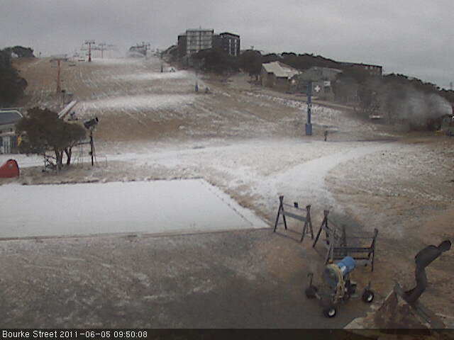
With a few centimetres of snow at Hotham and a dusting in the Buller webcam, the weather that was predicted for this weekend is beginning to deliver.
There wasn’t much concensus on the weather over the weekend itself, many predicted it to be mild and turning colder on Sunday night, so this was a welcome sight today. I was rugged up to go to the football last night and it remained mild and I was overdressed, but sitting outside at brunch this morning we were quite underdressed!
I wrote a post on Medium/Short Range Weather Forecasting last week, as much as a reference/link page for myself as anything, so I clicked on most of the links today and the overwhelming sense from them was positive.
It looks like we will see another front over Sunday night which will be cold and bring a small amount of snow, with yet another system looming on Tuesday that looks stronger. In addition to this the temperatures are set to remain cold for next week which will allow snowmaking.
Jane’s Weather is particularly bullish, as is the BOM Vic Alpine page. Weatherzone is not quite as excited however. The Weather Nerds are coming around as well, they were a lot more uncertain a few days ago but as the system gets closer naturally things are becoming more apparent.
So what’s the conclusion? I generally don’t like to make grand predictions, and a hell of a lot can happen in a week, but I would be very surprised if there wasn’t limited skiing at all the ‘Big 5’ resorts for Queen’s Birthday Weekend. Perisher is a no-brainer as they have already opened Front Valley, Buller should be able to open Bourke St, Falls with Towers and Drovers, & Merritts at Thredbo. I was at the footy last night with a senior Hotham person, they said that they are hoping for Summit, Big D & Road Runner on the weekend.
Who knows if it will pan out that way, but if the temperatures are cold enough we know that the snowmaking will supplement the natural snow, so it looks like there may be more than just drinking on the weekend.
What are your plans for the weekend? Will you head up for your first slide if there’s snow? Will you head up for the party anyway and snow is just a bonus?
