UPDATE: 8am Friday:
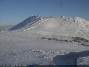
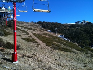
I have done some digging to find out if there’s more terrain opening at Buller on the weekend, the answer wasn’t too exciting “Same as last weekend with addition of Chute & Boomerang maybe”. However we do need to remember that prior to this snowfall was a tropical rainstorm which pretty much brought the natural snow cover back to zero, and no doubt affected the man made areas. As you can see from the photo, the fresh snow is no doubt welcome but not quite enough to open areas without man made snow.
So I’m looking forward to heading up tonight and a good weekend’s skiing, and I think it’s Sunday-Tuesday’s storm that should bring us up to 20cm of new snow that will allow the opening of new terrain. As I will be in New Zealand and therefore missing the next 2 weekends after this, Murphy’s Law dictates that the storm will be great and I will miss the 2 best weekends of the season.
UPDATE: 12:30pm Thursday:
Good blog post & pic from Snow-Blind.
Also the latest from Jane’s Weather:
Next weather system:
Approaches Victoria from the southwest on Saturday night. This system has NO tropical moisture, so no big deluge. A front should cross Victoria on Sunday, followed by another one on Monday or early Tuesday. This system has cold air with it, and it should be snow at the peaks from the beginning, before lowering throughout the alpine.
I am expecting just very light falls for anywhere well north of the Divide, and varying amounts between 5 and 20 mm on and south of the Divide – varying because this will be made up of showers which are convective based, and that activity is very hit and miss.
UPDATE: 10am Thursday:
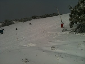
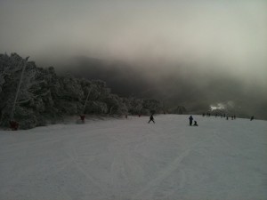
Some pics just sent by Drew Wilson:
UPDATE: 8am Thursday:
Well the results of the storm are welcomed. As there was pretty much zero natural snow for the rain to wash away, the result has been a nett gain with resorts reporting 20-30cm 24hour new snow totals.
We might see a few more cm from this storm, but it looks to be clearing with a follow up on Sunday-Tuesday next week. This one doesn’t look like being huge, but most likely won’t be preceded by rain either.
As usual I will update this through the day as I hear about skiing conditions.
UPDATE: 9:50pm Wednesday
Latest from luvthabumps (proprietor of the wonderful Village Square Cam) on the ski.com.au forums:
we have a winner just on the phone to jnr LTB now and made him go onto the balcony (where the cam is) with a ruler and the average depth is 22cm in the middle of the balcony (ranges from low 17cm to 30cm highest)
UPDATE 4pm Wednesday
A couple of SMS’s just received from the hill, hope you can decode the messages!
About 3-5cm last night…. But then it ‘snained’ all day til about 2:15 but it is puking now… Yay
AND:
Wet ice hail am snow flurries building to ok falls now still windy ocuple centimeters this arvo skiing miserable
UPDATE: 1:30pm Wednesday
Watch this space, this is the part we’ve been waiting for. The system is developing well, the radar is showing heavy precipitation heading towards the Alps.
I’ll update when I hear from people on the hill, but I like what I see.
UPDATE: 9:30am Wednesday
Just got a phone call from Hotham – it is dumping, full blizzard conditions.
Jane’s Weather has a good summary of what has happened, and what we can expect between now and Sunday/Monday
UPDATE: 8:30am Wednesday
Well it looks like the pessimism of the Weather Nerds wasn’t ill-founded. The trough delivered the rain that was expected, for much of last night it was 4-5c in the resorts and absolutely pouring. I got a few messages but they were too depressing to relay here.
The cold air arrived at about 1:30am but at that stage the precipitation pretty much dried up. Buller is reporting 3cm of new snow and the Village Cam tends to corroborate this.
Scattered showers are showing on the radar but a more substantial band of precipitation has just gone through Adelaide, so that is our next hope for some snow.
So it’s pretty disappointing at this stage, but not totally unexpected, as mentioned earlier in this post it’s a nervous situation when we’re relying on a cold front to combine with tropical moisture in exactly the right spot.
UPDATE: 4:30pm Tuesday
Just got messages from Buller and Hotham – it’s pouring (well they used another word beginning with P!)
ski.com.au Weather Forum members estimate the cold air will cross the Alps in approx 5 hours.
UPDATE: 1:20pm Tuesday
Here’s a message I just received from the hill:
The wind has picked up to an average of 90 km/h and gusting to above 120km/h.
Only blue bullet running.
Also scroll down to the comments to see a report from Lorraine Lock of snow-blind fame.
Thanks for the tips guys and I will keep updating as they roll in.
UPDATE 11am Tuesday:
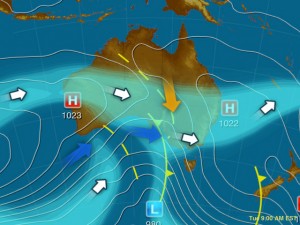
It’s basically a race between two arrows. The red one is the warm precipitation being sucked in from the tropics by a dirty great trough. The blue one is a good ol’ fashioned cold front.
That the red arrow will arrive first is a foregone conclusion, but it’s the timing of the blue one that will determine our fate. Some of the most epic snowfalls have been produced by the coming together of tropical moisture and cold antarctic air, but the combination and timing needs to be just right. It’s a nervous setup, and I will take a SW Cold Outbreak any time.
The moisture will hit this afternoon, and it seems like the more northerly resorts will be the most affected, both by the rain and the subsequent snow. As usual, Jane’s Weather has a good description of what to expect in layman’s terms:
It is too warm for snow in the alpine areas to begin. This precipitation will fall as rain this afternoon and tonight. It will quickly change to snow around 9 or 10pm at the western mountains and around midnight in the northeast (early Wednesday in NSW). Then the snowline should quickly lower to around 1000 metres. The weather models show that this scenario would add up to:
* 40+mm of rain, followed by 20 to 30 cm of snow in the northeast;
* around 20mm of rain, then 20cm of snow near Buller;
* and 5mm of rain, followed by 20cm of snow at Baw Baw.
Conditions ease gradually from the northwest on Thursday and Friday.
There appear to be two cold fronts coming after that, linked to the same upper weather pattern and cold air. The first is on Sunday and the second early next week. These don’t have tropical moisture linked to them that would make it to southeastern Australia, so it is just what we get from the west. That equals little for areas well north of the Divide, but all snow for the alpine areas.
Others aren’t as confident, most notably the Weather Nerds however they are much more excited about the follow up system.
So it could be a matter of closing your eyes today and tonight, and hoping to see some white on the cams this morning. I’m expecting SMS updates from friends on the mountains and will update this post when received.
UPDATE 1pm Monday:
Things are looking more positive for a series of fronts over the weekend and into next week. I am pretty loath to get excited about things that far out so I’ll be a little measured in my expectations, but at this early stage the signs are good. I’ll have a closer look this evening and add in some of the links I have been looking at, however as I will miss the 2 weekends following this one for my trip to NZ, that definitely makes me think it’s going to snow!
Meanwhile Drew Wilson sent me this photo from the hill today (at least it’s sunny!):
UPDATE 9pm Sunday:
Instead of dwelling on the weekend just gone, I think it’s time to think positively and look ahead to the snow coming this week.
I enjoy being right, in fact I absolultely love it, but it didn’t bring much joy to have accurately predicted what would happen over the weekend – anyway that’s what aussieskier.com is all about – helping readers make informed decisions about how the snow is looking.
So the weekend’s storm left the resorts in quite a state, but there is snow on the horizon. Once again it will commence as rain, but this time there is the potential for a decent amount of snow in its wake. As usual, timing will be of the essence, and while predicting when the cold air will allow the rain to turn to snow is something that’s pretty tough, I think there’s a concensus out there that it is going to happen this time.
Jane’s Weather has an excellent precis of the situation:
I am expecting rain to fall throughout the alpine areas from Tuesday afternoon until early Wednesday morning. It will then change to snow and the snow line should rapidly lower to the base of the alpine resorts. Rain out ahead may be as much as 50mm but then the last bit of the tropical moisture should fall as snow, plus everything we then get from the cold front. All up around 20cm. Baw Baw should miss most of the moisture again, but also get some good snow in the cold part. Snow on Wednesday followed by snow showers on Thursday and perhaps a little more on Friday.
The EC weather model then has a nice three pronged snowy cold front attack coming from next Saturday through to Monday. The US doesn’t like it as much.
Weatherzone is particularly optimistic, forecasting as much as 40cm of new snow, and Snowatch calling for only marginally less. BOM says Blizzards for Wednesday.
The Weather Nerds are a bit gun-shy after the series of ‘fizzer’ fronts this year, but keep watching the thread as the thread as the fronts approach, similiarly the Observations Thread will be worth watching once it arrives.
I love the anticipation when a storm is coming, and lord knows the resorts need it, and will be keeping you updated through the week.



Well I will be going next weekend anyway no matter what happens.
Yep hoping it’s a good one!
fingers crossed.
Is this the best snow realted website ever????
Yes.
Yes it is.
I love seeing the ‘Real’ pictures that you post up, unlike the ones taken by resort managment and touched up to look good! Keep up the good work!
12:40pm right now its windy, foggy and rainy
and hard to believe I know, but there is a big queue at the bottom of BB1…must be those keen SASKI skiers
Is it snowing yet? I’m dying to know what its like up there!
Comments are closed.