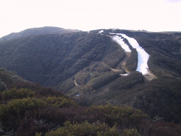
We have been pretty fortunate over the last month with regular storms and periods of poor weather. There is nothing worse at the start of a season than relentless clear skies which make for snowmaking and nothing else. I was going through some old photos over the weekend and found some pictures from the school holidays during the awful season of 2001. My squad and I climbed up Little Mt Buller and the only white stuff you could see for a 360 degree panorama was the snowmaking on LBS/Wombat:

Not all the precipitation this year has been of the white variety, but as all regulars will know – a good season in Australia means poor weather/visibility, so rug up and deal with it, and wait for spring if you want nice weather.
This year looks to be no exception. The weather over the weekend looked pretty awful with the arrival of a rain band as predicted later this afternoon. This looks to have turned to heavy, wet snow at Hotham Village level as reported earlier today, but by the distinct lack of enthusiasm on my Facebook feed I doubt very much that it has turned from rain at Buller – and by looking at the combination of BOM AWS and Radar rain would seem the obvious conclusion. Not that you would know from the official channels, for almost the last fortnight Buller’s social media communication has totally sidestepped the issue of snow, weather & conditions and is spruiking lame gimmicks instead. Oh well, guess that’s what I’m here for.
The forecast for the week looks encouraging, however it could be a mirror of the week before last. That particular storm was kind of like a shit sandwich – rain, followed by snow, followed by rain, after which we ended up just about exactly where we started. This week’s storm is evidently starting as rain, but looks to continue to snow for as far as anyone is game to forecast.
Jane’s Weather is particularly optimistic:
ALPINE FORECAST
REST OF TODAY:Light, patchy rain turning to proper rain this afternoon. From the evening: a wet snow/rain mix around 1500 metres but snow above this elevation, heavy at times later.
MONDAY: A wet snow/rain mix around 1500 metres, but snow above this elevation, heavy at times early. Easing during the day but increasing to heavy again at night, falling as snow throughout the alpine elevations.
TUESDAY: Heavy snow throughout, easing by the afternoon.
WEDNESDAY: Heavy snow throughout.
THURSDAY: Snow easing early.HOW MUCH?
20 to 30 mm of rain this afternoon.
Sunday night into Monday morning: 10 to 20 cm snow above 1500 metres.
Monday night into Tuesday morning: 10 to 20 cm snow throughout.
Wednesday: 20 to 30 cm snow throughout.
So that is 40 to 70 cm from tonight through to Thursday.
Then more snow later Friday into Saturday.
Just like in business I tend to halve snow predictions to see if I am still happy with them, and in this case even with far less than forecasted we will be a lot better off.
Weatherzone is on board, with particularly encouraging snow levels through to next weekend, Snowatch is a little less enthusiastic, though I note that it was updated yesterday morning – no doubt a day with the family is a much better option than poring over the charts for the Frog on a miserable Sunday. The Weather Nerds are all on board, the main question for them is how far the series of fronts will extend.
Anyway, this is all old hat to me. I washed my car today, of course there will be a week of wet weather.
Overall it looks encouraging, and no doubt will be well received by the hordes of holiday makers on the hill. After a lovely wedding last night and an excellent Bombers win as well, I would imagine that I will be up at Buller every weekend until October, unless the temptation of a quick long-weekend Heliskiing in NZ gets the better of me. That said, things have been pretty grim in NZ and it will only be in the next week or so that they receive their first significant natural snows of the winter. This has to be a bit of a kick in the guts for the Christchurch/Canterbury region, as if their tourist industry hasn’t been harmed enough by the earthquakes. The Aussie dollar goes a long way these days, and what better way to help our neighbours out than to pop across and check out the club fields – we had a great trip over there last year.
I will be keeping a close eye on things this week & regularly updating the site, as it looks to be the kind of weather event that could really kick start the season (yes, yes I know I said that a fortnight ago), but if you have your own thoughts on the forecast or some observations from up on the mountains, please use the comments below to let me know our opinion.
Don’t forget to ‘Like’ aussieskier.com on the top RHS of this page, and use the links below to share this article with your friends.


