

UPDATED: Fri 29th June 11:45am:
After what has been a warm & windy night in the mountains the cold is approaching – it was spelled out clearly in Jane Bunn’s Forecast that this one was going to start as rain and transition to snow during today. Texts from Buller and Facebook Updates from Hotham are suggesting that the temperatures are right on the borderline & that it is snowing up high.
Some good news is that the Buller Mountainwatch LBS Cam now seems to be working again – this is a very useful camera in storm times as it is often below the clouds.
Once again all the resources in my ‘How To Track A Snow Storm‘ post are most relevant today. Click through to get access to all the web links to keep you informed as the storm approaches.
The approach of the cold air is visible in the all-knowing Weather Chaser Satellite/Radar – you can see the speckled cloud marching across from the Vic/SA border quite nicely.
Mountainwatch’s ‘Grasshopper’ has also done a dodgy photoshop on the Satellite picture showing the key points:
His full description is on his Facebook Page
As I mentioned below in the early part of this post while the main pundits have been calling for decent snow amounts, the guys in the ski.com.au Weather forum have been less optimistic about the amounts of snow set to fall, and they have also concurred with my earlier thought that this system could favour Vic over NSW, and even in a more micro-scale it could further favour the southern resorts like Buller/Baw Baw.
Personally, I’m happy that it’s going to snow, but I’m not pushing the hype-meter into ‘extreme’ due to these doubts – in my opinion this will be a nice little snowfall that will get a bit more terrain open and will be welcomed by the hordes of school holiday makers arriving in the mountains in the coming days.
I will be up at Buller for the weekend and I would love for those in the other mountains over the weekend to keep us posted with updates on our Facebook Page and also tag some Instagrams with #aussieskier to appear on https://aussieskier.com/social
Don’t forget to ‘Like’ us on Facebook and Follow us on Twitter for the latest from this storm. I will update this forecast daily, or as required if anything changes.
Eagle-eyed readers will see a change to the homepage and an additional Gear section – I will be working hard on that in the coming weeks, reviewing as much as I can. Also if you have used any of the featured gear please add your own reviews, and contact me on [email protected] if you would like a particular item added.
Finally I’ve done a huge amount of ‘under the bonnet’ work on the website to speed it up – for the nerds who are interested it basically involves caching and offloading much of the content to a CDN. For the non nerds – it will load faster and piss you off less. 🙂
[divider]
ORIGINAL POST: Wed 27th June 2012 5pm:
After a bout of fine midweek weather to top off the snowfalls of the weekend, we have another weather system incoming that is forecasted to bring some more snow to the Alps.
Jane’s Weather is usually the first of my many bookmarks that I check out when there is a sniff of incoming weather. Here is her take:
A high pressure system is moving to our east, continuing the dry weather for now.
A cold and snowy outbreak is coming this weekend. A front moves through on Friday, introducing a cold and unstable airmass. This is driven by a low pressure system that will move across Tasmania on Saturday. It eases with a high coming closer on Monday.
Expect persistent snow through the weekend. Freeze levels lower well below 1200 metres after a wet rain/snow mix on Thursday night and Friday day.
How much…
Friday night to early next week: 20 to 35 cm.
The Frog is calling for similar amounts, as is Weatherzone and Mountainwatch.
It is rare to see such tight consensus from the major Australian snow forecasting pundits, and while the BOM is less specific when dealing with snow amounts, their forecast concurs that we will see snowfall across this period. Their 4 Day Forecast chart is also quite a pretty sight.
However the vibe in the ski.com.au Weather Forum is a little tempered due to questions over the amount of precipitation on offer.
One of the forecast charts posted there is quite indicative of this – showing that the MSLP and Thicknesses are consistent with a good winter weather system but the precipitation numbers are not indicating a huge dump:
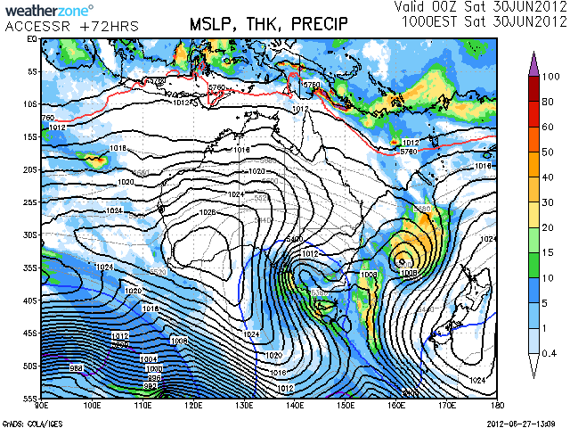
Most of the charts shown on the forum page indicate much of the moisture to the South, so in this case this system could slightly favour the Victorian resorts over NSW.
I will be up at Buller for the weekend and I would love for those in the other mountains over the weekend to keep us posted with updates on our Facebook Page and also tag some Instagrams with #aussieskier to appear on https://aussieskier.com/social
Don’t forget to ‘Like’ us on Facebook and Follow us on Twitter for the latest from this storm. I will update this forecast daily, or as required if anything changes.
